Phase 1 Exploration Plans
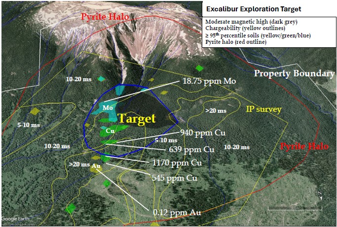
A one-week mapping and prospecting program was completed on July 29, 2025 with 15 rock samples submitted for assay. Fieldwork identified chalcopyrite mineralization outcropping within a copper-in-soil anomaly and mapped several newly identified diorite porphyry intrusions. Some of these porphyries exhibited feldspar replacement by epidote, which may represent propylitic-style alteration characteristic of peripheral zones in porphyry systems.
The Company has secured a permit exemption for its planned ~20 line-km Induced Polarization (IP) survey over key copper anomalies. Contractor selection is underway, and the survey is expected to be completed in September 2025.
The IP program at Excalibur will include line-cutting to support up to a 20 line-km of IP survey at a line spacing of 200 m and in the vicinity of the high Cu soil samples collected in 2019 and 2021. Mapping, prospecting and sampling are proposed to be conducted along the cut-lines. A recent property visit by management of Prospect Ridge has confirmed that commercial logging activity has opened up access to the target area for the IP survey.
The object of the Phase 1 program is to define drill targets for a minimum 2,000 metre diamond drill program contemplated for spring of 2026, pending receipt of drill permits.
Acquisition Terms
Under the terms of the Agreement, which has been approved by the Canadian Securities Exchange (“CNX”), Prospect Ridge can earn a 100% interest in the project by completing the following:
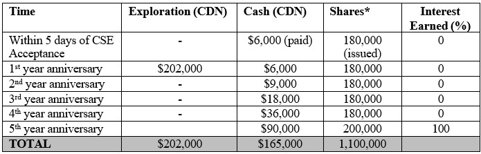
* Shares valued at the greater of the 10 day volume weighted average price or discounted market value prior to each anniversary date.
Once Prospect Ridge has completed the Phase 1 work program and paid the initial share and cash compensation it may elect to return all or part of the project to the Vendors with two years good standing and an additional three years of assessment applied on those claims that have passed their ten year anniversary date. Providing that Prospect Ridge continues to make cash and share payments on the anniversary dates it will earn a 100% interest in the project, subject to a 1.5% NSR royalty in favour of the Vendors of which 0.9% can be bought for $400,000 on or before the first NI-43-101 indicated mineral resource, $800,000 on or before the publication of a scoping study (PEA), and at anytime thereafter for $1,600,000.
The Vendors will also be entitled to annual Advance Royalty Payments (“ARP”) of $6,000 per year commencing on the sixth anniversary of the Acceptance Date and increasing to $12,000 per year commencing on the eleventh anniversary of the Acceptance Date and then increasing to $18,000 per year
commencing on the fifteenth anniversary of the Acceptance Date and continuing for as long as Prospect Ridge or successor owns the permits. All amounts provided as ARP can be paid in shares, at Prospect Ridge’s option and will be deductible from future NSR royalty payments.
First Nations Land Acknowledgement
Prospect Ridge acknowledges that Excalibur is situated within the traditional territory of the Lake Babine First Nation. Prospect Ridge is committed to developing positive and mutually beneficial relationships with First Nations based on trust and respect and a foundation of open and honest communications.
Sources of Technical Information
- Awmack, J. 2019. Geological and Geochemical Report on the Jacobite Project. B.C. Mines Branch Assessment Report 38665
- Bultitude, and Lui, D. K. 2021. Geophysical Report on the Jacobite Project. B.C. Mines Branch Assessment Report 40035
- Awmack, J. 2022. Geochemical Report on the Jacobite Project. B.C. Mines Branch Assessment Report 40867
Qualified Person Statement
All technical data, as disclosed on this website, has been verified by Ron Voordouw, Ph.D, P.Geo. Director of Geoscience for Equity Exploration Consultants Ltd., a consultant to the Company and a qualified person as defined under the terms of National Instrument 43-101.
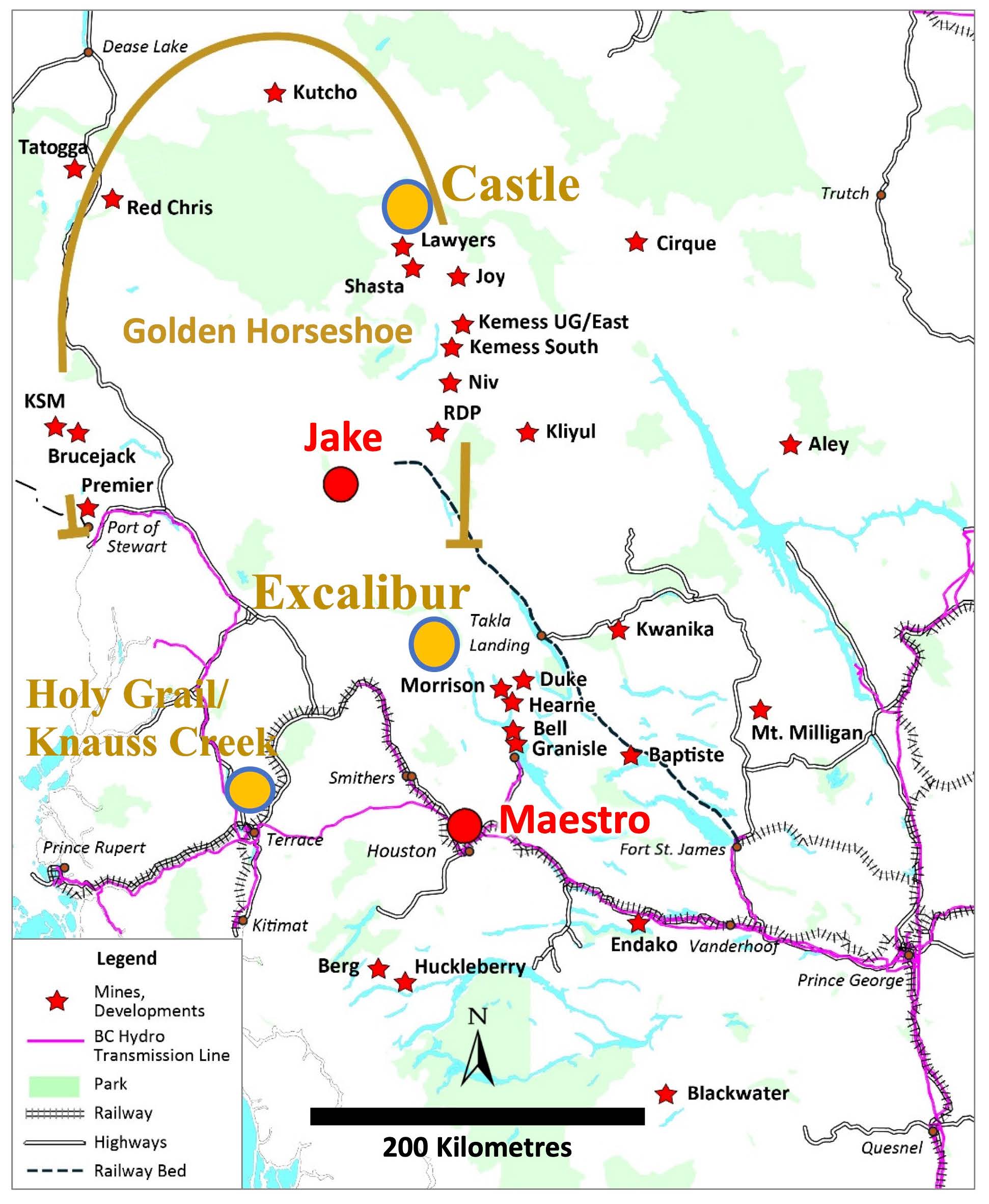 Figure 1 – Excalibur property location in relation to Prospect Ridge’s Holy Grail/Knauss Creek and Castle projects, historic mines and the new Quartz Mountain Resources Ltd. Jake and Maestro discoveries